Koh Phi Phi and the 2004 Tsunami: What Happened, How Many Died, and What You’ll Find Today
Table of Contents
On 26 December 2004, one of the deadliest natural disasters in recorded history hit the Andaman coast of Thailand, and Koh Phi Phi took some of the worst of it. The Boxing Day tsunami killed an estimated 1,000 to 4,000 people on the island alone (the true toll was never confirmed), destroyed around 70% of its buildings, and reshaped the physical landscape in under three minutes.
If you’re travelling to the Phi Phi Islands today, you’ll find a place that has, against considerable odds, rebuilt itself into one of Thailand’s most visited destinations. But knowing what happened here in 2004 adds real meaning to any visit. It also explains a few things about the island’s layout, its evacuation signs, and the small memorial park sitting quietly in the heart of Tonsai Village.
What Was Koh Phi Phi Like Before the Tsunami Hit?
By December 2004, Koh Phi Phi Don had cemented its reputation as one of Southeast Asia’s most popular backpacker and resort destinations. Its fame had surged after the release of The Beach (2000), partly filmed at Maya Bay on Phi Phi Leh. Tonsai Village, the island’s only real settlement, was packed with guesthouses, dive shops, bars, and restaurants clustered on a narrow, flat strip of land between two bays.
That geography would matter enormously on the morning of 26 December.
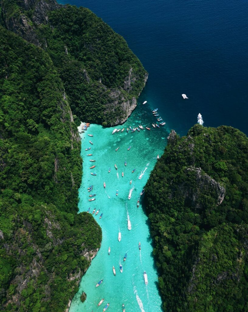
Phi Phi Don is shaped roughly like a figure eight: two hilly limestone masses connected by a low, flat strip of land (called a tombolo) about 800 metres wide. Tonsai Village, along with most of the island’s hotels, restaurants, and infrastructure, sat on this low section between Tonsai Bay to the south and Loh Dalam Bay to the north. At its highest, this central strip sat no more than two metres above sea level.
Boxing Day fell during peak tourist season. Hotels were full, beach bars were open, and the beaches were lined with sunbathers. Nobody on Phi Phi had any warning of what was coming.
How the Tsunami Hit Phi Phi: A Timeline of Three Waves
At 7:58 am on 26 December 2004, a magnitude 9.1 earthquake ruptured off the coast of Banda Aceh, northern Sumatra, the third-largest earthquake ever recorded. The energy displaced billions of tonnes of ocean water and sent waves outward in every direction.
Two hours later, at approximately 10:29 am local time, the first wave reached Phi Phi Don’s western shore.
The waves didn’t come from a single direction. Because of the island’s position and shape, the tsunami wrapped around both sides of the limestone cliffs at the same time. Water surged into Tonsai Bay from the south. Almost simultaneously, it flooded Loh Dalam Bay from the north. The two waves converged on the flat isthmus from both sides — no high ground within reach, almost no time to get there.
Three distinct waves hit:
- Wave 1: Flooded Loh Dalam Bay and pushed water across the isthmus
- Wave 2: Destroyed all wooden structures, including bungalows, beach bars, and smaller guesthouses
- Wave 3: The largest; it demolished stone and concrete buildings
The entire sequence lasted three minutes, from 10:29 to 10:32 am. In those three minutes, around 70% of Tonsai Village was flattened.
Approximately 4,000 people are believed to have died on Phi Phi, though the exact figure will never be known. Many bodies were never recovered. Some estimates, combining confirmed deaths with the missing, put the toll considerably higher.
Why Was Koh Phi Phi Hit So Hard?
The island’s geography made it almost uniquely vulnerable.
Most other Thai coastal areas hit by the tsunami faced a wave from one direction. Phi Phi’s tombolo position meant it was struck from both sides at once, removing any chance that one side might shield the other. The flat, low-lying isthmus offered no natural protection, as you can see clearly on our Phi Phi Islands map.
The absence of any early warning made everything worse. Unlike the Pacific, which has had a tsunami warning network since the 1940s, the Indian Ocean had nothing in place in December 2004. Residents and tourists had no idea what was coming. Many had never heard the word “tsunami” at all.
Khao Lak, north of Phuket, suffered even greater casualties, partly because a broad, shallow offshore shelf amplified the wave height. At Phi Phi, it was the pincer geography, the dense population on the flat isthmus, and the complete absence of warning that combined to such devastating effect.
Who Was on the Island That Morning?
December is peak season in the Phi Phi Islands. Post-Christmas travellers, local Thai residents, and island workers meant the number of people on the low-lying isthmus was unusually high.
The island population that morning included:
- Thai residents and fishing families who had lived on Phi Phi for generations
- International tourists from Europe, Australia, North America, and Asia
- Seasonal workers from mainland Thailand and other provinces
- Boat operators and crew anchored in Tonsai Bay
Among those who died were three Irish nationals: Lucy Coyle, Eilis Finnegan, and Connor Keightley, along with victims from dozens of countries. Many bodies were never formally identified, which is part of why the total death toll remains disputed.
Survivors who reached the viewpoint hill above Tonsai, or who were already on the higher parts of the island around Laem Tong Beach, largely escaped physical harm. People already out at sea on dive or snorkel trips were also mostly unaffected. Tsunami waves pass under boats in deep water with little force.
The Immediate Aftermath: Rescue, Evacuation, and the Scale of Destruction
The hours after the tsunami were chaotic. Communications with the outside world cut out almost immediately: phone lines down, electricity gone, the ferry piers at Tonsai destroyed. Survivors gathered on hillsides and ridges, unsure whether more waves would follow.
Rescue boats and military helicopters began arriving within hours. By the evening of 26 December, nearly 500 casualties had been treated at Krabi Hospital alone, with more arriving through the night by boat and helicopter. Many were transferred to larger hospitals in Surat Thani and Songkhla for surgery.
A journalist who arrived days later described Tonsai as looking like “the village had been picked up by some angry giant,” with debris piled metres high, boats deposited hundreds of metres inland, and concrete buildings reduced to rubble.
Cleanup and recovery took years. The underwater wreckage was so extensive that a commemorative site was later established at Ao Ton Sai, roughly three kilometres offshore, where divers place wreaths on debris that still rests on the seabed.
How Long Did It Take to Rebuild Koh Phi Phi?
Recovery moved faster than most people expected. Significant international aid helped, as did the Thai government’s and private operators’ determination to restore one of the country’s most economically important tourism destinations.
The rough timeline:
- 2005: Debris cleared, basic infrastructure restored. Some guesthouses and businesses reopened within months. Dive operators were among the first back, reporting that the underwater reefs had recovered quickly.
- 2006: Tourist numbers began to pick up. The island looked noticeably different: wider main streets, better drainage, evacuation routes clearly marked.
- 2007–2008: Most resorts and hotels had been rebuilt or replaced. In some respects, the reconstructed Tonsai Village had better infrastructure than before.
- By 2010: Visitor numbers had returned to, and in some periods exceeded, pre-tsunami levels.
One lasting change: the island’s footprint was partially redesigned during reconstruction. Areas previously built too close to the shoreline weren’t rebuilt, and evacuation routes to the viewpoint hills were formalised and signposted across the island.
The Phi Phi Tsunami Memorial Park: Visiting and What to Expect
The Phi Phi Tsunami Memorial Park sits in the heart of Tonsai Village, a short walk from the main ferry pier. It’s a small, quiet garden with memorial plaques, photographs from 2004, and a central monument.
Every year on 26 December, a memorial service is held here. Families and friends of victims travel to the island to lay flowers and observe a minute’s silence at 10:29 am, the exact moment the first wave struck. Divers place commemorative wreaths at the underwater site offshore.
If you visit, treat it with the respect it deserves. This isn’t a conventional tourist attraction. It’s a real place of grief for Thai families who lost everything here. Keep noise down, take any photos discreetly, and read the plaques if you want to understand the human scale of what happened.
Entry is free. The park is open during daylight hours, roughly five minutes’ walk from the main Tonsai pier, signposted from the main street.
What the Island Looks Like Today: Signs of the Past, Shape of the Future
Walk around Tonsai Village today and the tsunami’s legacy shows up in unexpected places.
Evacuation route signs are everywhere: white signs with blue arrows pointing uphill toward the viewpoint, on walls, at beach entrances, at the pier. These aren’t decorative. The Indian Ocean Tsunami Warning System, set up after 2004, includes detection buoys and coastal sirens. On Phi Phi, local residents receive regular training in evacuation procedures.
The Phi Phi Viewpoint, a steep 20-minute climb above Tonsai, is not just a great photo spot. It’s the primary high-ground refuge if a warning is ever issued. The path is clearly marked and maintained partly for this reason.
The layout of Tonsai itself differs slightly from pre-tsunami maps. Streets are a little wider in places. Some former beachside bungalow areas near Loh Dalam Bay, featured in our Phi Phi beach guide, were rebuilt further back from the waterline. That bay, which took the force of the first wave, is now home to the memorial and a quieter stretch of beach.
The island’s recovery is real. It doesn’t erase the history.
Planning Your Visit: Practical Notes for Travellers
If you’re visiting Phi Phi and want to pay your respects at the memorial, or simply understand the island’s history, here’s what you need to know.
Getting to Phi Phi: Ferries run daily from Phuket (Rassada Pier) and Krabi Town (Passenger Pier). Journey times are roughly 1.5 hours from Phuket and 1.5–2 hours from Krabi. High-season fares typically range from 350–500 THB (around $10–14 USD) each way. See our full guide to getting to Phi Phi Islands for current schedules and booking options.
When to visit: The dry season (November to April) offers clear water, calm seas, and reliable ferry services. Peak season (December–January) brings the biggest crowds. If you want to attend the 26 December memorial, book accommodation well in advance. The island is extremely busy over Christmas, and you’ll want to find accommodation on Phi Phi early.
The memorial: Free to visit, no booking required. Allow 15–30 minutes for a quiet stop. Morning visits are cooler and less crowded.
National Park fee: The Phi Phi Islands sit within Hat Noppharat Thara–Mu Ko Phi Phi National Park. An entry fee applies for international visitors (400 THB, roughly $13 USD as of 2026 — check current rates before you travel). This is collected at the pier on arrival.
An Honest Note for Visitors
The Phi Phi Islands sit in an active seismic zone. The 2004 event was exceptional in scale, a once-in-centuries occurrence, but seismic activity in the region is ongoing. Since 2004, Thailand and the broader Indian Ocean region have put a tsunami early warning system in place, with detection buoys and coastal sirens. On Phi Phi, evacuation routes are clearly signposted and local residents are trained in emergency procedures.
What this means practically: when you arrive, take a minute to note the evacuation route signs. They’re posted throughout Tonsai. The viewpoint hill to the east of the village is the designated high-ground refuge. If you ever hear sirens or feel prolonged ground shaking while on the island, move uphill immediately and don’t wait for confirmation.
This isn’t meant to alarm you. Phi Phi is safe to visit, and millions of people do so every year without incident. But knowing where to go in an emergency is just good travel sense.
A Traveller’s Perspective: Visiting the Memorial on a Day Trip from Phuket
My ferry from Phuket’s Rassada Pier left at 8:30 am and docked at Tonsai around 10:00. I had a snorkel day trip booked for the afternoon: Maya Bay, Pileh Lagoon, the works. But before that, I had an hour in the village, and I’d promised myself I’d find the memorial.
It took about six minutes to walk there from the pier, cutting through the narrow market street and following one of the blue signs. The park was quiet: a few Thai visitors, one older European couple reading the plaques slowly. The photographs from 2004 are stark. The flat isthmus completely underwater, building rooflines just visible above the flood.
I stood there for a while. The noise of Tonsai, the longtail boats, music from the beach bars, the smell of grilled chicken, felt very close and very incongruous. That contrast is the point, I think. The island is alive and busy and genuinely beautiful. And underneath all of that is a story worth remembering.
Ready to Visit the Phi Phi Islands?
Whether you’re planning a day trip, a multi-night stay, or want to book a snorkel tour taking in the iconic bays around Phi Phi Leh, our guides cover everything you need. Ferry times, hotel options, snorkel tours and day trips from the island, it’s all here.
Plan My Phi Phi Trip
Frequently Asked Questions
How many people died in the Phi Phi Islands tsunami?
The confirmed death toll on Koh Phi Phi was approximately 800–850, with a further 1,200 reported missing. Some estimates, including local accounts and researchers, place the combined figure at around 4,000 when accounting for unregistered workers and those whose bodies were never recovered. The true toll will never be known with certainty.
Was Koh Phi Phi rebuilt after the 2004 tsunami?
Yes. Recovery moved faster than many predicted. Basic services were partially restored within months, and the island was largely rebuilt by 2007–2008. The reconstructed Tonsai Village has wider streets and better-designed drainage than the original. Visitor numbers returned to, and eventually surpassed, pre-tsunami levels within a few years.
Is it safe to visit Koh Phi Phi now?
Yes. Millions of tourists visit each year without incident. Since 2004, Thailand and the broader Indian Ocean region have implemented a tsunami early warning system with detection buoys and coastal sirens. On Phi Phi, evacuation routes are clearly signposted and local residents are trained in emergency procedures.
Where is the Phi Phi tsunami memorial?
The Phi Phi Tsunami Memorial Park is in Tonsai Village, roughly five minutes’ walk from the main ferry pier. It’s a small, free-to-enter garden with photographs, plaques, and a central memorial monument. A ceremony is held there every year on 26 December at 10:29 am.
Why was Koh Phi Phi so badly affected by the tsunami?
Phi Phi’s geography made it particularly vulnerable. The island’s main village sits on a flat, low-lying strip of land between two bays: Tonsai Bay and Loh Dalam Bay. When the tsunami struck, waves entered from both bays at the same time, converging on the isthmus from both sides with no high ground in between. Combined with the complete absence of any early warning system, the result was catastrophic.
Did Maya Bay survive the tsunami?
Maya Bay is on Phi Phi Leh, the smaller uninhabited island in the Phi Phi group. The bay experienced significant wave action, but the dramatic limestone cliffs surrounding it deflected much of the force. The reefs and beaches needed time to recover naturally. Today, Maya Bay is one of Thailand’s most visited sites. It was closed to tourism from 2018 to 2022 to allow reef recovery, and has since reopened with visitor limits in place.